
Disasters Have Consequences
In freight transportation, like other critical infrastructures, there are cascading impacts with significant consequences when disruptions occur. In the aftermath of such disruptions, planners and policymakers are faced with tough choices in designing efficient response and recovery plans within their legal limits. With freight transportation, one of the challenges during disasters is to understand the operational and functional readiness of the infrastructure. This is not just a physical resiliency question, but also an institutional, managerial, and connectivity question.
In the aftermath of Hurricane Sandy, various observers noted the challenges with freight rerouting necessitated by this event as well as the perceived legal barriers involved with intermodal freight transportation. While the maritime sector was able to resume operations shortly after the storm dissipated, the damage incurred by the road and rail infrastructure left the Port of New York/New Jersey isolated from the national freight network until operations on these land-side modes could be restored.[1] In situations like this, the strategy of short sea shipping (SSS)—the coastwise movement of freight in territorial waters—is implemented to ease the challenges posed by damaged infrastructure. This is a popular transport strategy in Europe and Asia; however, it is illegal to implement such a strategy in the United States under the Merchant Marine Act of 1920, also known as the Jones Act. This puts more pressure on land-side modes to handle cargo surges at the targeted diversion ports and subsequent movements of the diverted freight.[2]
To analyze the implications of the Jones Act on freight transportation during disasters, we used the Transportation Routing Analysis Geographic Information System (WebTRAGIS), a multimodal routing analysis tool developed at Oak Ridge National Laboratory (ORNL), to model various modal scenarios. The preliminary analysis utilizes the road, rail, and water routes as potential transportation strategies for cargo diverted to various ports along the Eastern Seaboard. One of our initial conclusions is that the use of geographic information system (GIS) technology such as WebTRAGIS could help analysis and understanding of the effects of legal restrictions such as the Jones Act on the systems they govern.
Freight Transportation as Critical Infrastructure
As part of the 2010 National Infrastructure Protection Plan, the Department of Transportation (DOT) and the Department of Homeland Security (DHS), with input from the United States Coast Guard (USCG), submitted the Transportation Sector-Specific Plan.[3] The sector-specific plan is broken into seven subsectors, representing the major modes of transportation. Freight transportation is discussed throughout the various sub-sections, with the freight rail section particularly focusing on goods movement because of the heavy utilization of rail; however, no general freight sector is defined within the sector-specific plan.[4]
The Merchant Marine Act of 1920
The Merchant Marine Act of 1920, also known as the Jones Act, can be considered a cornerstone in U.S. maritime law. In addition to the cabotage law, the statute also provides basic rights of maintenance and cure to able-bodied seaman. Although recent focus on the Jones Act has been on its limitations on SSS, the original intent of the cabotage law was military preparedness. Over time, courts have interpreted the Act as an “unabashedly protectionist” law in contrast to its original intent.[5] Over time, this viewpoint has been adopted by other judges deciding cases relating to the Jones Act and its effect on cabotage for the United States.
Under the provisions of Jones Act, “no merchandise shall be moved between coastwise points in the United States unless the vessel is built in an American shipyard and has the requisite number of American crew members onboard.”[6] The court in Furie Operating Alaska v. U.S. Dept. of Homeland Security noted that a violation of the Jones Act can result in forfeiture of the merchandise transported, a penalty “equal to the value of the merchandise (as determined by the Secretary of Homeland Security), or the actual cost of the transportation, whichever is the higher penalty.”[7] In contrast to the Transportation of Passengers[8] and Towing[9] statutes, the civil penalties are steeper for a Jones Act violation with the potential that the cargo is forfeited.[10]
Within the statute, there is opportunity to receive a waiver to commence SSS operations. Both approaches require agency evaluation of whether there are sufficient vessels in service such that a waiver is not necessary or that the movement of such cargo is in the interest of the national defense interest of the United States. As the Furie case concluded, such decisions are unreviewable by Article III courts as the decisions are “committed to agency action” since the law is so broad such that “there is no law to apply” and no standards exist for judicial review.[11]
WebTRAGIS: A GIS Application for Transportation Routing Analysis
Over the past thirty-five years, ORNL has developed various models for transportation routing analysis for spent nuclear fuel shipments. Through several iterations, the TRAGIS program developed into the current WebTRAGIS model. WebTRAGIS is a thin client-based program developed to be accessible over the Internet with an easy to use Graphical User Interface (GUI).[12] In contrast to the previous models, WebTRAGIS offers a more detailed representation of the rail, road, and water networks for the United States.[13] Using data from the U.S. Geological Survey Digital Line Graphs, the U.S. Census Bureau Topologically Integrated Geographic Encoding and Reference (TIGER) System, the U.S. Army Corps of Engineers, the Federal Motor Carrier Safety Administration, the Federal Railroad Administration, as well as high-resolution satellite imagery, the various networks have been developed to represent the actual U.S. road, rail, and waterway systems used for commercial or hazardous materials transportation.[14]
Hurricane Sandy and Impacts on Freight Transportation
Hurricane Sandy was a multi-storm event, which hit the East Coast of the United States in October 2012. Starting on October 22, 2012, the National Oceanic and Atmospheric Administration (NOAA) began tracking the storm in the Caribbean.[15] According to National Cooperative Freight Research Program Report 30, Hurricane Sandy affected all modes and freight facilities, particularly the Port of New York/ New Jersey, which is under the jurisdiction of the Port Authority of New York and New Jersey.[16] The port handles over 3.2 million containers annually and is a major economic engine for maritime and transportation operations on the East Coast.[17]
When the Port of New York/New Jersey announced the suspension of operations, Customs and Border Protection (CBP) put out a message through the Cargo System Messaging Service (CSMS), alerting incoming vessels that they would need to divert to other ports along the East Coast, such as Boston, Philadelphia, Baltimore, Norfolk, Charleston, and Savannah.[18] As a result of the closure of the Port, between 15,000 and 25,000 containers as well as 9,000 automobile imports were diverted to other ports along the eastern seaboard.[19] According to local news reports, the Port of Norfolk received approximately 6,500 containers, while other containers were diverted to the other ports listed in the CSMS bulletin.[20]
Freight infrastructure in the New York metropolitan area was devastated. Debris and containers were washed into the waterways, causing hazards to navigation, as well as damaging navigational aids. From the perspective of the land-side modes, the damage was also severe. Drayage trucks that support moving containers away from the quayside were damaged, blocked by debris, or washed away.[21] The access roads to terminal property were damaged by the saltwater that flooded coastal areas as a result of the storm surge.[22] Although railroad engines and cars were moved out of the storm’s path, the storm damaged the port’s dock-rail infrastructure, with the CSX Kearny yard in Essex County flooded by four feet of water.[23]
One transport strategy was not utilized in the immediate aftermath of the storm. Under the Jones Act,[24] only the U.S. flagged vessels could move between two U.S. ports. Because of this law, foreign vessels were not allowed to engage in coast-wise shipping. Although the Jones Act can be suspended, and has been suspended in similar events such as Hurricane Katrina, the Jones Act was not suspended until a fuel shortage developed in the New York City area after a subsequent winter storm struck the region.[25]
Scenario Development in WebTRAGIS
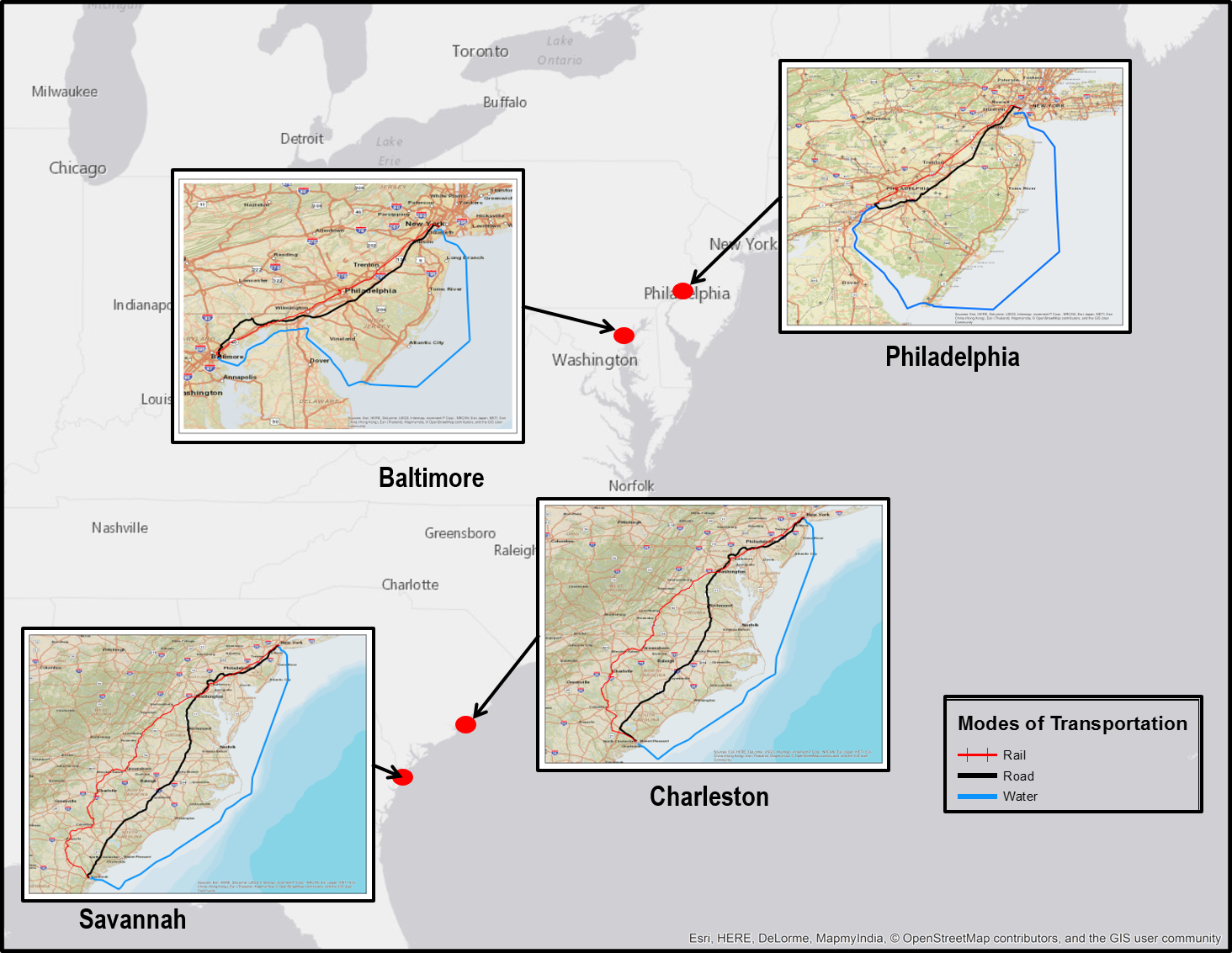
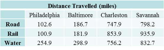
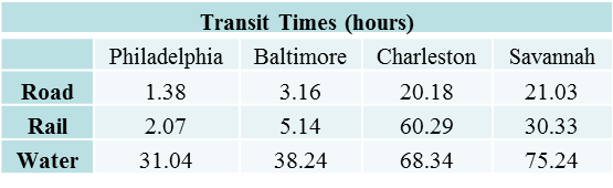
Using WebTRAGIS, four scenarios were developed taking into account the port closure at New York/New Jersey and the diversion to three other ports along the East Coast according to the CBP CSMS Bulletin. In each of the scenarios, the port receiving diversion traffic is the origin for the route and the Port of New York/New Jersey is assumed to be the destination for the route. In reality, freight will travel from the port receiving diverted traffic directly to its ultimate destination, but because these destinations are unknown, the Port of New York/New Jersey is used as the destination in the routing scenarios.
Within each scenario, three modal routes are generated: a road route, a rail route, and a water route. For the rail mode, WebTRAGIS requires an originating and terminating railroad company as part of the initialization and operation of the routing algorithm; for the scenarios, the originating and terminating railroads were set to be the same. For each port, a water route is also generated to represent waterborne transportation under a SSS policy regime. Under this policy regime, cargo is loaded onto vessels and moved between two ports within U.S. territorial waters as another option for cargo routing. Figure 1 highlights the results from the scenarios generated within the program. Within each inset are the three modal scenarios illustrating the route from the diversion port to the Port of New York and New Jersey.
Results and Discussion
We reported four scenarios representing the diversion ports and the various routes available to get freight from the port of diversion to its “ultimate” destination, in this case, the Port of New York. To summarize those findings, the following tables are offered to illustrate the various distances, transit times, and impedance values for the routes generated in WebTRAGIS. The impedance value can be described as a distance/time frictional factor for how much “resistance” the given route will present once generated.
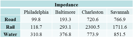
Focusing specifically on the water routes, the underlying assumption in the generation of these routes was that the United States embraced SSS as part of a national freight transportation policy. Because of the Jones Act and the restriction on the type of vessels that can engage in the practice of SSS, the strategy is severely limited. The water route had a lower impedance value than that for the rail route. It should be noted that cross-modal comparison cannot be made because each mode has different operating characteristics which are unique to that mode; for example, the rail impedance value was heavily influenced by rail ownership transfer as seen in the Charleston scenario where water routes did not have any penalization. However, because the impedance value in general can be described as how much “resistance” the given route will present, the argument can be made that from a network perspective, water routing should be considered a viable option for freight transportation systems, especially in the context of disaster response and recovery efforts.
Conclusions
Using applications such as WebTRAGIS, Geographic Information System technology can help illustrate various options with respect to transportation rerouting in the event of extreme weather or other compromises to the national transportation sector, especially under scenarios where transportation infrastructure is inoperable as a result of infrastructure damages. The utility of platforms like WebTRAGIS is in the ability to provide visualization and detailed routes for decision-makers in reviewing plans, policies, and laws that could make critical infrastructure more secure and resilient in the face of uncertainty.
Biographies
Marc Fialkoff is a doctoral candidate in the Planning, Governance & Globalization program in the School for Public & International Affairs at Virginia Tech. He received a law degree and a masters in sustainability in transport from the University of Leeds. He is currently on a research appointment to the Critical Infrastructure & Climate Impacts Team at Oak Ridge National Laboratory. His research focuses on freight transportation planning, law, and critical infrastructure resilience and security.
Olufemi Omitaomu is a Senior Research Scientist and Team Lead of the Critical Infrastructure and Climate Impacts Team at Oak Ridge National Laboratory. He also is the theme lead for Urban Resiliency team within the Urban Dynamics Institute. He received a PhD in Industrial Engineering from University of Tennessee Knoxville, where he holds a joint faculty appointment in the Department for Industrial & Systems Engineering.
Acknowledgement
The first author would like to acknowledge the funding support of the Global Security Directorate at Oak Ridge National Laboratory during his 2015 Summer Internship in the Geographic Information Science and Technology Group at Oak Ridge National Laboratory. The authors acknowledge the support of Benjamin Thomas Jr. and Steven Peterson of Oak Ridge National Laboratory for this project. This manuscript is authored by an employee of UT-Battelle, LLC, under contract DE-AC05-00OR22725 with the U.S. Department of Energy. Accordingly, the United States Government retains a non-exclusive, paid-up, irrevocable, world-wide license to publish or reproduce the published form of this manuscript, or allow others to do so, for United States Government purposes. The Department of Energy will provide public access to these results of federally sponsored research in accordance with the DOE Public Access Plan (http://energy.gov/downloads/doe-public-access-plan).
References
[1] Tiffany Smythe, Assessing the Impacts of Hurricane Sandy on the Port of New York and New Jersey’s Maritime Responders and Response Infrastructure, Report no. 238 (University of Colorado Natural Hazards Center, 2013), https://hazards.colorado.edu/uploads/quick_report/smythe_2013.pdf.
[2] See The Merchant Marine Act of 1920, 46 U.S.C § 861 et. Seq (1920); Smythe, supra note 1.
[3] Transportation Systems Sector-Specific Plan: An Annex to the National Infrastructure Protection Plan (Department of Homeland Security, 2010).
[4] Ibid.
[5] William H. Yost III, “Jonesing for a Taste of Competition: Why an Antiquated Maritime Law Needs Reform,” Roger Williams University Law Review 18, no. 1 (Spring 2013): 52-77. http://docs.rwu.edu/cgi/viewcontent.cgi?article=1517&context=rwu_LR.
[6] The Merchant Marine Act of 1920, 46 U.S.C § 861 et. seq. (1920).
[7] Furie Operating Alaska, LLC v. U.S. Dep’t of Homeland Security, No. 3:12-CV-00158 JWS, at *2, (D. Alaska March 27, 2014), http://cases.justia.com/federal/district-courts/alaska/akdce/3:2012cv00158/48218/123/0.pdf?ts=1436261210.
[8] Transportation of Passengers, 46 U.S.C. § 55103 (2006).
[9] Towing, 46 U.S.C. § 55111 (2006).
[10] Ibid.
[11] Ibid. at *9.
[12] P.E. Johnson, & R.D. Michelhaugh. Transportation Routing Analysis Geographic Information System (TRAGIS) User’s Manual, report no. ORNL/NTRC-006 (Oak Ridge National Laboratory 2003), http://web.ornl.gov/~webworks/cppr/y2003/rpt/118270.pdf (revision).
[13] Ibid.
[14] See Ibid.; Paul Johnson, “WebTRAGIS, A Routing Model for the 21st Century,” (Oak Ridge National Laboratory, 2001), http://web.ornl.gov/~webworks/cppr/y2001/pres/115157.pdf.
[15] Frank Southworth, et al., Making U.S. Ports Resilient as Part of Extended Intermodal Supply Chains, Report no. 30, (National Cooperative Freight Research Program, 2014).
[16] Ibid.
[17] Ibid.
[18] “Hurricane Sandy Interim Processes for New York and Newark Related Cargo,” Customs and Border Protection Cargo Systems Messaging Service, CSMS #12-000488 (Nov. 2, 2012), http://apps.cbp.gov/csms/viewmssg.asp?Recid=19046 (CSMS Bulletin sent to Automated Broker, et al.).
[19] Lombardi, D., Small Sea Changes: Big Coastal Impacts-Port of NY & NJ Sandy 2012, The Port Authority of New York New Jersey (2014).
[20] Bill Crezenzo, “Hurricane Sandy Sent Extra Cargo to Port,” Inside Business: The Hampton Roads Business Journal, Nov. 9, 2012, http://insidebiz.com/news/hurricane-sandy-sent-extra-cargo-port
[21] Southworth, supra note 13.
[22] Ibid.
[23] Ibid.
[24] The Merchant Marine Act of 1920. 46 U.S.C § 861 et. seq. (1920).
[25] “Secretary Napolitano Issues Temporary, Blanket Jones Act Waiver,” U.S. Department of Homeland Security, accessed June 15, 2016, http://www.dhs.gov/news/2012/11/02/secretary-napolitano-issues-temporary-blanket-jones-act-waiver.