
by Megan Clifford, Lawrence Paul Lewis, Frédéric Petit, Duane Verner, and Thomas A. Wall
Risk and Infrastructure Science Center
Global Security Sciences Division, Argonne National Laboratory
Introduction
The National Climate Assessment and Development Advisory Committee (NCADAC) recognizes that essential local and regional infrastructure systems, such as water, energy supply, and transportation, will increasingly be compromised by climate change impacts. Furthermore, climate-related disruptions of services in one infrastructure system will almost always result in disruptions in one or more other infrastructure systems.[1] Changing climate conditions in the United States, from rising sea levels to increasing temperatures, are already taxing communities and infrastructure systems; however, the majority of cities and urban areas have not yet integrated adaptation activities into their long-term planning.[2]
Given that the impacts of climate change are most often experienced at a regional or local level, effective adaptation in a locally relevant context requires that decision makers have access to actionable information and analytical guidance.[3] However, State, local, and private sector officials frequently highlight gaps in local-level modeling, climate scenario data, and local planning frameworks as barriers to climate change adaptation.[4] Available data are often developed by and for the atmospheric and oceanic science communities. These projections of future climate conditions are not easily translated into local climate impacts; yet it is the impacts that are more directly actionable through engineering design, infrastructure management, and community planning practices. Infrastructure professionals and policymakers will be better equipped to develop climate change adaptation strategies if locally focused climate projections and guidelines are available for their use.[5] In this article, we discuss the gap between existing climate science capabilities and critical infrastructure adaptation needs and propose a potential path forward.
Generating Actionable Climate Data for Current Design Practices
The scientific community’s understanding of changing global climate systems is currently based on a class of models known as general circulation models (GCMs), also called global climate models, that project climate across the globe with a coarse spatial resolution (i.e., large grid squares often more than 100 km wide). Statistical techniques and regional climate models are frequently used to regionalize, or downscale, the global climate model outputs and increase spatial resolution (Figure 1).
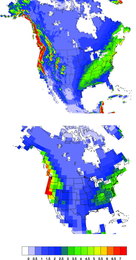
Figure 1: Average winter precipitation rate (mm/day) for a 10-year period (1995 to 2004) as simulated by a regional climate model with 12-km spatial resolution (top) and a global climate model with 250-km spatial resolution (bottom).[6] Credit: Jiali Wang, Argonne National Laboratory.
For example, the U.S. Department of Defense (DoD) Strategic Environmental Research and Development Program (SERDP) Climate Change Impacts to DoD Installations project[7] generates climate projections for the North American continent at 12-km grid sizing. Although these downscaled models may produce outputs containing climate variables (e.g., precipitation, temperature) with regionally or locally relevant spatial scales, climate model outputs do not always immediately translate or easily convert into climate impacts, such as flooding or drought, which are the types of criteria used in engineering design or infrastructure management activities. Bridging this gap is further complicated because much of engineering design is predicated on designing for the reasonable worst-case or extreme condition, which often requires factors other than the average values typically generated by climate models. For example, drainage systems may be designed for the 50-year flooding event (i.e., occurs only once every 50 years, or has an annualized average likelihood of occurrence of 2%). To consider climate change in this design, engineers must first determine how the climate model output (precipitation) will translate hydrologically into surface water runoff or flooding, and then determine to what extent the climate model output reflects extreme precipitation, and therefore extreme runoff. Engineering and infrastructure management and design practices are currently not equipped to bridge this gap between climate variables from model outputs and climate impact information necessary for adaptation.
One way to address the gaps between climate modeling and infrastructure design is greater cooperative engagement between climate scientists and stakeholder groups responsible for regional or local infrastructure planning, design, and development (e.g., departments of transportation, city planning). A wide variety of models and tools have been developed to better inform engineering design and to characterize critical infrastructure impacts. However, these tools may require further modification to incorporate future climate impacts. Climate scientists and planning, design, and development professionals working together to augment current modeling practices, or develop new ones that make use of available data, may lead to more actionable adaptation solutions that address location-specific climate impacts. Such increased cooperative engagement between State, local, and private-sector stakeholders and climate scientists enables direct communication of local and regional needs, which scientists can take into account as they continue their research and refine their approaches. Furthermore, it is also important to have climate modeling results that are expertly translated into formats that can be used to directly support engineering analyses.
A U.S. Department of Homeland Security (DHS) Regional Resiliency Assessment Program (RRAP) project studying climate change impacts on critical infrastructure in Maine is one example where this cooperative approach to developing and applying actionable climate data through community engagement is being used.[8] In support of this RRAP, Argonne National Laboratory (Argonne) infrastructure specialists and climate and environmental modelers are partnering with State and local stakeholders in Maine to better understand flooding effects in the Casco Bay Watershed, which includes the Portland metro area. Climate modelers at Argonne have developed region-specific climate projections, and hydrologists at Argonne are working with State and local counterparts to develop locally relevant intensity-duration-frequency (IDF) curves for the watershed. Engineers use IDF curves to understand how precipitation events translate into surface runoff water and inform the design of hydraulic infrastructure, such as culverts and drainage systems. Typically, IDF curves are based on historical rainfall data. However, for the project in Maine, Argonne is developing “next-generation IDF curves” that will reflect future climate conditions and inform climate-resilient designs in the region for the future.
Enhanced Understanding of Climate Data among Local User Communities
In addition to having actionable data, State, local, and private-sector stakeholders also need guidance to help them better understand the uncertainty, biases, and potential limitations of the climate data sets and how best to take action given these considerations. User guides could be developed similar to the Federal Emergency Management Agency (FEMA) Risk Management Series[9] to provide background methodology and “how to apply” guidance in a form most suitable for each stakeholder group. From a modeling perspective, user guides could provide decisionmakers with (1) a critical overview of relevant downscaling models, methodologies, and data sets; (2) the advantages and disadvantages of each method; (3) geographical dependence of bias for each method (e.g., systematic under- or over-prediction of climate impacts); and (4) uncertainties associated with the downscaling process and climate data in general.[10]
It is also important that these guides inform stakeholders at the outset of adaptation activities on how best to reconcile climate data considerations with potential action plans. For example, should a stakeholder consider climate projections that predict mid-century or end-of-century impacts? Because climate models are based upon sets of emission scenarios that to some extent correspond with the severity and timing of impacts, which emission scenario(s) should stakeholders consider? Climate scientists may have an understanding of the tradeoffs among these considerations, but by engaging cooperatively with local, State, and private-sector stakeholders, the scientists can support development of locally relevant guidance to best inform adaptation planning and action.
Climate data and information are only useful if readily comprehensible to users. Strong visualization tools are one way to enhance stakeholders’ understanding of highly technical data sets and analyses related to climate change and resilience. The stakeholder community will be instrumental in determining the specific details and functionality of the visualization tools. Potential characteristics may include:
- Web-based, to facilitate open access by as broad a user community as possible;
- Tiered, to address the particular needs of different audiences; and
- Interactive, to allow users to view, select, and query underlying data sets and analytical results derived from those data sets combined with time-sliding capabilities that provide an intuitive way to understand potential impacts (e.g., interactive maps, charts, and time-series plots).
Conclusion
Effective adaptation of critical infrastructure systems requires actionable and locally relevant climate change impact data. However, the gap that exists between current climate model data outputs and the local planning and design inputs necessary to initiate adaptation activities presents a barrier to this effort. Collaborative engagement between climate scientists and planning, design, and development professionals can lead to useful resources and tools for communities addressing climate change. The diversity of these unique regional and local needs exemplifies the importance of partnerships that make the nationally available climatological data sets relevant to local infrastructure management and engineering practices. Actionable climate data and enhanced understanding will help break the barrier to climate change adaptation for critical infrastructure.
Acknowledgment
The work presented in this article was partially supported by Argonne National Laboratory under U.S. Department of Energy contract number DE-AC02-06CH11357. The submitted manuscript has been created by UChicago Argonne, LLC, Operator of Argonne. Argonne, a U.S. Department of Energy Office of Science laboratory, is operated under Contract No. DE-AC02-06CH11357. The U.S. Government retains for itself, and others acting on its behalf, a paid-up nonexclusive, irrevocable worldwide license in said article to reproduce, prepare derivative works, distribute copies to the public, and perform publicly and display publicly, by or on behalf of the government.
[1] “Understand Climate Change,” GlobalChange.gov, accessed Aug. 5, 2015, http://www.globalchange.gov/climate-change.
[2] Jeremy G. Carter, Gina Cavan, Angela Connelly, Simon Guy, John Handley, and Aleksandra Kazmierczak, “Climate Change and the City: Building Capacity for Urban Adaptation,” Progress in Planning 95 (Jan. 2015):1–66, available at http://www.sciencedirect.com/science/article/pii/S0305900614000397.
[3] Ibid.
[4] Chase Raines, “Climate Adaptation: A Survey of Concerns Facing Organizations,” Association of Climate Change Officers, March 2013, http://www.accoonline.org/downloads/ACCO-Report-AdaptationSurvey-March2013.pdf.
[5] Jim Collins, “Zooming In: From Global to Regional Climate Models,” Argonne National Laboratory, July 8, 2015, https://www.alcf.anl.gov/articles/zooming-global-regional-climate-models.
[6] Ibid.
[7] “Climate Change Impacts to Department of Defense Installations,” SERDP and Environmental Security Technology Certification Program (ESTCP), accessed June 20, 2015, https://www.serdp-estcp.org/Program-Areas/Resource-Conservation-and-Climate-Change/Climate-Change/Vulnerability-and-Impact-Assessment/RC-2242.
[8] “Working with Regional Partners to Examine the Impacts of Climate Change,” U.S. Department of Homeland Security, accessed July 29, 2015, http://www.dhs.gov/blog/2015/05/07/working-regional-partners-examine-impacts-climate-change.
[9] “Security Risk Management Series Publications,” Federal Emergency Management Agency (FEMA), last updated March 5, 2015, https://www.fema.gov/what-mitigation/security-risk-management-series-publications.
[10] “Climate Change Impacts to Department of Defense Installations.”